How To: Read Weather Forecasts for Backcountry Skiing
Snow is science. Learning to understand the intricacies of snow and mountain weather takes a lifetime. In no way am I claiming to have mastered this detailed, complex subject. Every day I venture into the mountains I learn something new about weather forecasting. I am obsessed with weather, especially in the wintertime.
Below are 5 tips and pointers that I’ve found to be very helpful, specifically when planning backcountry ski tours.
#1: Reference MULTIPLE weather tools…not just one
Professional forecasters use what is called an ‘ensemble’ weather model, which takes many different predictors, simulations, data points, and averages them out to spit out a ‘forecast’. In this same way, it’s important for you to reference multiple different weather sources.
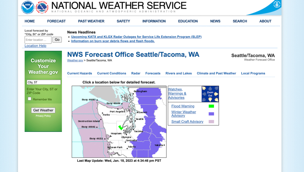
Weather.Gov
My go-to weather source is Weather.Gov, specifically the ‘Forecast Discussion’ that is put out regionally by the National Weather Service for your particular area. Here’s an example for the homepage for the Pacific Northwest region around Seattle.
Each day the office will describe in detail the weather pattern for the next 1-2 days, as well as give an ‘extended forecast discussion’ for the 7-10 day outlook. They often reference a few ‘models’: the ECWMF or ‘Euro’ model, the GFS or Global Forecast System, and the ICON model, a German weather model.
Windy.com
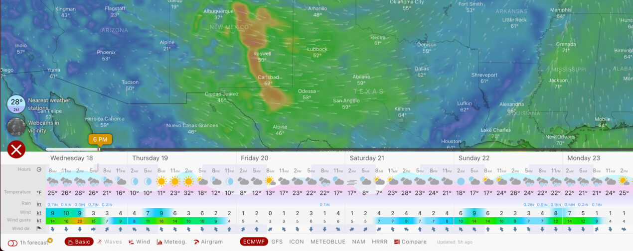
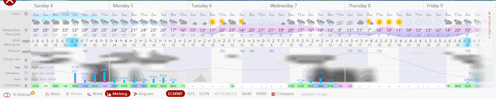
My favorite mobile app for weather is Windy, by FAR. I love the fact that you can toggle between the different weather models (GFS/ECWMF/NAM/ICON). The ‘meteogram’ is specifically valuable for looking at clouds, cloud deck, and overall atmospheric conditions.
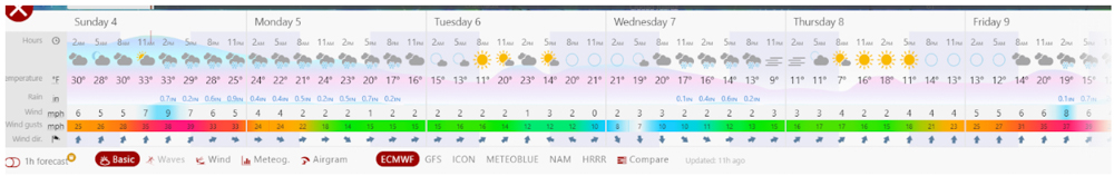
In this first image, you can see a forecast in the “basic’ view for the ECWMF (which is the default). You can toggle to ‘Meteog’ (which stands for Meteogram) to see more detail on cloud cover, etc.
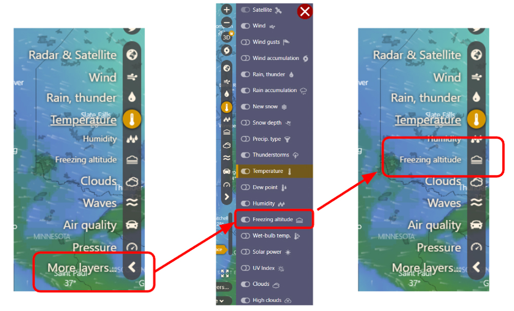
Windy also has great features such as:
- Viewing the freezing altitude on a geospatial map
- Viewing the snow totals for a specific area on a geospatial map
- You can set alerts for specific areas depending on if you want to know snow totals, wind speeds, etc.
#2: Freezing Levels are KEY
Utah claims to have the ‘best snow on earth’, whereas Washington State is infamously known for its ‘Cascade Concrete’. Why’s that?
Two main factors: humidity and freezing levels. I’ll speak here about freezing levels specifically.
Freezing altitude is the elevation at which the air temperature is 32F: freezing. For skiing, this is very important because it impacts the density and quality of the snow that falls. If you’re planning to ski at 5,000’ and the freezing levels are 3,000’, chances are you will have great, lightweight snow. If you’re planning to ski at 5,000’ and the freezing levels are 4,500’, the snow will be heavier… but still good. If you’re planning to ski at 5,000’ and the freezing levels are 5,000’… well, be prepared for some heavy mush.
Long story short, the lower the freezing level, the ‘lighter’ and more ‘powdery’ the snow. Freezing level is a great metric to look for specifically in a weather forecast for backcountry skiing. I always check it before leaving the house. I like using Windy’s freezing levels, which you can overlay on both their mobile and laptop applications.
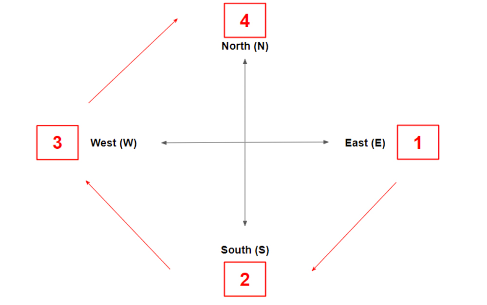
#3: Aspects MATTER
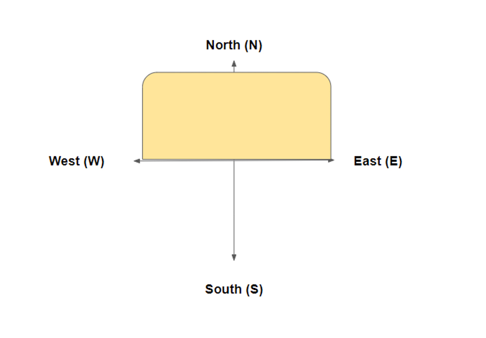
Aspect, or the cardinal direction a slope is facing, is critical for skiing. Good aspects for skiing change from season to season. I’ll try to summarize, in general terms, how the aspects differ from Winter to Spring.
Winter
In the wintertime, when the sun is lower in the sky, north aspects will typically hold the best snow. They will get the least amount of sunshine because they are in the shade most of the day. East aspects will typically get early sun and can develop ‘solar crusts’ because they get that warm morning light. West aspects are similar to north aspects, although they receive a little more sun later in the day than north aspects will. South aspects will receive the most sun and will typically develop strong solar crusts and be prone to wet avalanches because the sun is hitting them for most of the day.
Wind matters a lot with aspects too, depending on the prevailing direction in your region. But if you’re just thinking about sun, for the wintertime north (N) and west (W) are typically your best bets.
Spring
Spring means chasing ‘corn’ snow, which is formed by repeated freeze-thaw from the sun and dropping night time temperatures. Solar aspects are critical in the springtime when chasing ‘corn-o-clock’. In general, you can think of the aspects similar to a ‘clock’.
East (E) aspects will warm and soften the earliest in the day, since they receive the morning sun. Ski these first.
South (S) aspects will receive sun next and warm the next soonest.
Next are west (W) aspects, then north (N) aspects (which receive the least amount of sun and will have generally harder snow throughout the day).
You can think of the compass like a clock. First east, then south, then west, then north.
#4: Learn the prevailing wind directions for your area
Each region has a ‘prevailing’ wind direction, meaning the direction the wind will most frequently travel. In the continental/Rocky mountain region, this can often be easily noticed based on which slopes are ‘rocky’ and wind scoured and which slopes hold snow. Either way, it’s very useful to learn which direction the wind most frequently blows so that you can understand how the snow will fall and where it may be building up.
The best way to learn prevailing wind directions is to track the wind speed and wind direction day-to-day over the course of the season. You will find that there are common wind directions during storm systems. If you don’t have this luxury, you can find local climate summaries HERE for your local area. There are average temperatures, wind directions, etc. for many areas.
#5: Track the Snow Water Equivalent to Snow Depth
‘Snow Water Equivalent’ or SWE determines how much water is in the snowpack. It’s a great metric for understanding the density of the snow. In the northwest, we typically have a SWE of 1:10, meaning 0.1” SWE will correspond to 1” of snow. In drier climates like Utah, they may get ratios of 1:15 or even 1:20.
The higher the ratio, the lighter the snow. Many telemetry stations will report SWE and snow depth, but SWE is often the better metric to track because sometimes the snow depth meter gets blown away by the wind.
Knowledge is Your Best Tool!
The best tool for your backcountry outings is knowing what to expect. By tracking the weather and understanding aspects, freezing levels, prevailing winds, and SWE, you’ll be prepared to travel efficiently and effectively. Weather in the mountains can change rapidly, but it always helps to be one step ahead and understand what is going on before you head out.
About the Gear Tester

Sam Chaneles
Sam Chaneles is an avid mountaineer and backpacker, climbing peaks in the Cascades, Mexico, Ecuador, and Africa, as well as hiking the John Muir Trail and off-trail routes in Colorado. He has climbed peaks such as Aconcagua, Mt. Rainier, Cotopaxi, Chimborazo, Kilimanjaro, and many more. Sam graduated with a B.S. in Mechanical Engineering from Georgia Tech. During his time there he was a Trip and Expedition Leader for the school’s Outdoor Recreation program (ORGT). He has led expeditions to New Zealand, Alaska, Corsica, France, and throughout the United States. Sam is based in Issaquah, WA just outside of the Cascade Mountains. You can follow Sam and his adventures on Instagram at @samchaneles, or on his website at www.engineeredforadventure.com.
-
Sam Chaneles#molongui-disabled-link
-
Sam Chaneles#molongui-disabled-link
-
Sam Chaneles#molongui-disabled-link
-
Sam Chaneles#molongui-disabled-link